— Dare Medflight installed Skytrac high resolution cameras in its H145 helicopter.
DARE COUNTY, NC — Dare MedFlight, an air medical transport operator serving Dare County, N.C., has completed installation of Skytrac’s high resolution aviation camera on its Airbus H145 helicopter.
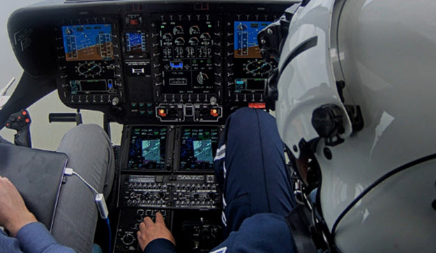
The cover photo of this article is the H145 Flight Deck visuals captured during demo flight out of Dare County Regional Airport in Manteo, N.C., in May 2018. Source: Skytrac Photo
The Skytrac aviation camera is designed to provide operators with highest fidelity audio visual recording during flight while also minimizing the need to change data cards or over-write stored data.

The device allows operators to record every action taken by pilots and crew inside the cockpit of the helicopter.
According to SkiesMag, the Dare MedFlight program manager explained the need for the device as follows:
“As an air ambulance operator, we have a mission to deliver safe, efficient and reliable service. We look to the latest technologies to support us in this mission. Adding a high-resolution camera to the flight deck provides a new, objective input for our safety management programs and allows us to enhance training for our pilots.”
Skytrac offered a lightweight and cost-effective option that could easily be retrofitted on our HEMS-equipped H145T2,” said Dare MedFlight director of operations, Chad Jones.
The Skytrac aviation camera is designed to provide operators with highest fidelity audio visual recording during flight while also minimizing the need to change data cards or over-write stored data.
It is capable of recording up to eight hours of video at 1080p and 15 fps. The camera comes in a unique kit format that allows up to two flush-mounted lenses to be installed internally or externally.
Wide lens and fine detail image sensor kits are available to accurately record flight controls and capture maximum field of view.
The camera kit can be used with Skytrac’s ISAT-200A transceiver and data acquisition unit or as standalone hardware to supplement existing flight data monitoring and tracking solutions.
[two_column_block style=”undefined”] [content1]

[/content1] [content2]

[/content2] [/two_column_block]
[two_column_block style=”undefined”] [content1]

[/content1] [content2]

[/content2] [/two_column_block]